Marmitte dei Giganti
Accesso al fosso Anguillaja: parcheggiato l’automezzo a margine della strada provinciale di Val d’Arni (687 m di quota), che conduce verso Castelnuovo Garfagnana, ci si incammina a piedi lungo una vecchia carrareccia, che si apre sulla sinistra e discende verso la Tùrrite Secca. Dopo 250 m si raggiunge il corso d’acqua che, di regola, si presenta completamente secco, poiché caratterizzato da una circolazione subalvea. Dopo aver percorso il fondo arido in direzione nord, mentre l’asta fluviale disegna un meandro incassato, si incontra subito la confluenza da sinistra del fosso Anguillaja (650 m di quota), in gran parte modificata dai vecchi tagli e dai residui abbandonati di una cava di marmo. L’attività estrattiva ha pure cancellato le prime ‘marmitte’ che esistevano nella parte più bassa dello stesso fosso, sagomando artificialmente il suo fondo e le sue pareti laterali.
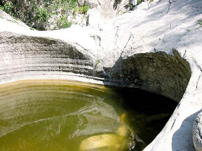
L’Anguillaja è un corso d’acqua intermittente a regime temporaneo, in occasione di piogge consistenti, che presenta alcune notevoli ‘marmitte’, descritte per la prima volta da Masini (1929). A quel tempo, gli ultimi 300 m del fosso discendente dal M. Sumbra, mostravano ben 13 grandi cavità a paiolo. Il loro numero si è poi ridotto per le distruzioni prodotte anni fa dalla cava dismessa del suo tratto inferiore. Le ‘marmitte’ superstiti, oggi tutelate dal Parco Regionale, sono facilmente osservabili proseguendo il breve itinerario lungo l’Anguillaja. La risalita del fosso è relativamente facile all’inizio e, il primo salto morfologico, viene superato grazie ad una piccola scala in ferro. Si giunge così alla successione spettacolare di tre ‘marmitte’ di proporzioni rilevanti, completamente scavate nel marmo (vedi foto a lato).
Più oltre, il percorso richiede pratica nell’uso della corda doppia e nell’arrampicata d’aderenza su roccia.
Morfogenesi: le ‘marmitte dei giganti’ devono spesso la loro origine all’azione abrasiva di ciottoli ruotanti. Lo sviluppo richiede più condizioni coincidenti, tra cui il movimento vorticoso della corrente fluviale e un substrato roccioso coerente ed omogeneo, come il marmo del M. Sumbra.
A questo modello sembrano riferirsi anche le ‘marmitte’ dell’Anguillaja e del Fatonero, come dimostrerebbero i segni dell’erosione meccanica sui bordi interni della grande cavità a paiolo raffigurata a lato.
Tuttavia, alcuni Autori hanno ipotizzato una genesi di queste ‘marmitte’ in regime forzato, attraverso cunicoli subglaciali che dovevano trovarsi nel versante meridionale del Sumbra e del Fiocca, in corrispondenza di ghiacciai o nevai perenni formatisi durante l’ultima glaciazione.
Per altri, la dissoluzione chimica (carsismo superficiale) può aver preparato inizialmente le cavità, su cui l’azione idrodinamica ha poi avuto ragione prevalente o esclusiva (Federici et alii, 1981).
Un sguardo al fosso Fatonero, al Fiocca e al Sumbra
Dalla strada provinciale di Val d’Arni, 700 m più a monte dell’Anguillaja, è facilmente individuabile il fosso Fatonero, di cui si possono osservare gli ultimi 400-500 m di tratto, discendenti dal M. Fiocca. Le ‘marmitte’ sono state numerate in modo decrescente al risalire del fosso: in tutto sono 21 e di dimensioni analoghe a quelle del fosso gemello. Anch’esse sono scavate nel Marmo.
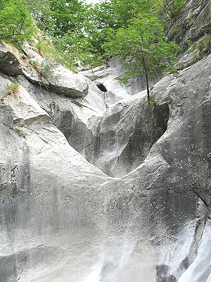
Nel risalire il M. Fiocca, dal fosso Fatonero, s’incontrano, in successione, Marmi, Calcari selciferi, Diaspri, Calcari selciferi ad Entrochi, Scisti sericitici e Pseudomacigno, con diverse ripetizioni dovute a pieghe minori. Si segnala anche la presenza di tre minuscole klippe di Calcare cavernoso. Il M. Sumbra invece, è costituito prevalentemente da Marmi e Calcari Selciferi. I versanti meridionali di questi due rilievi sono caratterizzati soprattutto da forme di modellamento carsico e glaciale. I solchi arrotondati della parete sud del Sumbra sono legati a processi crionivali, dovuti a nevai perenni o a piccole masse effimere di ghiaccio.